As I had back to back meetings around DC and various fires to put out most of the day today, so I unfortunately didn't get to enjoy the ESRI Federal User Conference (FedUC) yet. Tomorrow looks promising, though- I have a few things going on in the AM but it looks like I'll be able to break away to attend the afternoon.
I'm looking forward to it....
In the meanwhile, today revealed a few wonderful insights and excellent opportunities for future projects in rearchitecting core GIS processes for one of our major customers... Hopefully I will be able to reveal some of this exciting news in months to come.
Meanwhile I'm hunkered down in my hotel room awaiting the State of the Union address... should be interesting to see what the Bush vision for the near future is...
FedUC redux...
ESRI Federal Users Conference Tomorrow...
 I'm registered for the ESRI Federal Users Conference tomorrow through Thursday... I'm looking forward to seeing the speakers, vendors, exhibits and old cameraderies, particularly our friends, partners and folks that we have done work with over the years, like Metacarta, SRA International Inc., Topcon Positioning Systems, Inc., BAE Systems ADR, i-cubed, Michael Baker, GeoDecisions, Trimble, Thales Navigation, Safe, and others... however things are going to be tough.
I have quite a few other meetings around the DC area booked throughout the week as well. I'm hoping to do a couple of hit-and-run attendances throughout the week but as far as any substantial block of time, it looks rough.
For anyone else who is thinking about attending but who doesn't have the info, I'd highly recommend it...
http://www.esri.com/events/feduc/index.html
Hope to see you there!
Technorati tags:
aerial photography, analysis, applications, arcgis, arcgis desktop, arcgis explorer, arcgisexplorer, arcgisserver, arcims, arcsde, arcweb, business, cartography, e-government, esri, esri developer network, events, federal, geo, Geospatial, gis, gps, mapping, metacarta, navigation, professional, remote sensing, spatial, usgs, webmapping
Global Warming reshaping the map
Recently there have been a few articles about political unrest between the US and Canada over coastal waters, to include the Canadian military patrolling these waters with armed icebreakers.
The main cause for concern is the reduction in surface area of multiyear ice along with a thinning of ice, which is working toward making the Northwest Passage across northern Canada a viable alternative for shipping. The Northwest Passage would present a route that is potentially up to 7,000 km shorter than using the Panama Canal. Canadian journal The Tyee has an interesting article that spells out and clarifies some of the specific issues and concerns, mainly revolving around policing and operations, such as liability issues associated with an arctic shipping route- oil spills, along with concerns about overexploitation of arctic fisheries, and the potential for entry of illegal weapons, drugs, or movement of WMDs by rogue nations.
Additionally the Tyee article lays out some of the history and confusion over ownership, with many arguments to either side about territorial waters and what Canada may or may not have legal jurisdiction over.
Certainly some very valid and important issues, which I hope our US diplomats can come to terms with and in fact offer a means of working with them together on, as opposed to butting heads. Currently it's my understanding that quite a bit of the cross-continental truck traffic in the US actually makes its way across from Pacific port to Atlantic port without a US destination in between- yet another sign of the intense demand for Atlantic/Pacific logistics. I would expect that a monitoring solution would include satellite-based remote sensing and communications platforms...
Technorati tags:
arctic, business, Canada, diplomacy, earth observation, emergency response, environment, environmental protection, exploration, geo, Geography, geopolitics, global warming, history, mapping, navigation, news, opinion, policy, remote sensing, rescue, satellite, security, stewardship
Not on the map?
The GeoCarta blog discusses an article in the Rock Hill Herald (South Carolina), lamenting the latency in mapping data updates compared to the rapid development in many suburban areas with the sprouting of new residential developments right and left. Oh, the inconveniences of newspaper delivery, having to give directions, not being able to verify addresses in automated systems.
Missed the point on two much bigger and more serious issues that this rapid residential development also dredges up:
Emergency Response- without adequate mapping, emergency services must rely on verbal directions to dispatch and route responders, with risk of unfamiliarity with new developments and a potential for reduced response time.
Urban Sprawl- It points up the continuing trend of urban sprawl and conjures up all of the associated issues of wasteful land use and the decline of cities, increased need for infrastructure and increased dependency on vehicles, increased commute times, et cetera...
My humble opinion, I think someone's issues with home delivery of the newspaper pales in comparison...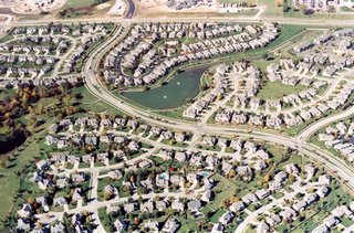
Technorati tags:
activism, architecture, blog, cartography, community, design, developer, emergency response, environment, geo, Geography, gis, land ownership, mapping, navigation, news, opinion, planning, real property, sprawl, stewardship, sustainable development, urban sprawl
Beautiful maps and a look back in history...
Almost 20 years ago, practically right out of high school and through college, I started working in a surveyors' office- one that had tens of thousands of old plats and maps, some of which dated back to the turn of the century... I just love looking at old time surveyors' drawings from that time period- the lettering, the care and time they took drawing them just amazes me.
Claus Moser's Kartentisch blog discusses a site that has some gorgeous maps drawn by an Austrian surveyor named Johann Orth. I was reading Orth's story on the site- fascinating stuff. He was born 1929, pressed into service in the military for the tail end of WWII at the age of 16, ended up in a russian POW camp, and after the war worked as a surveyor, photogrammetrist, and cartographer for the Austrian government for 47 years, until he retired in 1981.
Since then he's been hand-drawing maps in that old style of what Vienna and various cities and places in Austria would have looked like at various points in time, going back two hundred years in time, based on his research and work with an Austrian museum- his maps are absolutely gorgeous.
Planauswahl (Index of plans)
Technorati tags:
Austria, blogs, cartography, design, geo, Geography, history, map, mapping, maps, photogrammetry, surveying , symbolization, Vienna
ESA Vegetative study via satellite
ESA News has a great article talking about a ten-year study called GLOBCARBON, which uses terabytes of data from multiple satellites and sensor platforms to analyze global vegetation patterns.
The service is focused on the generation of various global estimates of aspects of terrestrial vegetation: the number, location and area of fire-affected land, known as Burnt Area Estimates (BAE), the area of green leaf exposed to incoming sunlight for photosynthesis, known as Leaf Area Index (LAI), the sunlight actually absorbed for photosynthesis, known as the Fraction of Absorbed Photosynthetically Active Radiation (fAPAR) and the Vegetation Growth Cycle (VGC).
To obtain these products, GLOBCARBON blends data from a total of five European satellite sensors: the VEGETATION instruments on SPOT-4 and SPOT-5, the Along Track Scanning Radiometer-2 (ATSR-2) on ERS-2, plus the Advanced Along Track Radiometer (AATSR) and Medium Resolution Imaging Spectrometer (MERIS) on Envisat.

Technorati tags:
agriculture, analysis, applications, earth observation, environment, esa, geo, Geography, Geospatial, gis, imagery, mapping, news, remote sensing, satellite, science, space, spatial, SPOT, vegetation
The other exciting release- ArcWeb Explorer
The new ArcWeb Explorer has been released to public beta. It shows a "sexy" new UI, using Flash 8 and SVG, for client-side dynamic refreshes, reducing server round-trips. With all the hype around similar AJAX-based offerings like the popular Google and Live Local offerings, along with others like the new Yahoo maps and Map24, it's sure to generate its own share of buzz. The only downside is the interface doesn't have that "drag to pan" capability that everyone loves- but given the SVG orientation, I'd say the infrastructure is already in place to make draggable maps an imminent possibility.
What's even more exciting, is the possibility of ArcIMS-based offerings for the enterprise using this technology as well, given the rumors floating around about what's in the works for 9.2.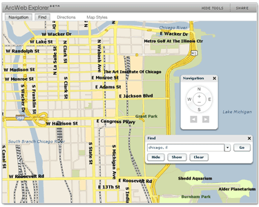 Try the new ArcWeb Explorer out here: http://redlandsarcweb.esri.com/explorer/index.jsp
Technorati tags:
ajax, arcgis, arcgis explorer, arcgisexplorer, arcgisserver, arcims, arcweb, esri, esri developer network, Flash, geo, Geospatial, gis, Google, Java, JSP, livelocal, map, mapping, maps, microsoft, microsoft atlas, news, SVG, UI, user interfaces, web services, webmapping
Carbon Project WMS, WFS and GML support for ArcGIS
 The Carbon Project, which is an effort to provide open source GIS tools for Open Geospatial Consortium interoperability using .NET, has made a new tool available for ArcGIS Desktop- CarbonArc. CarbonArc is an extension for ArcGIS that allows an ArcGIS client to access OGC-compliant Web Map Services (WMS), Web Feature Services (WFS) and Geographic Markup Language (GML).
While ESRI's Data Interoperability Extension also provides this functionality, along with offering a whole host of other interoperability options, the ability to have a simple extension for OGC-only will be good for many organizations, because the ESRI Data Interoperability Extension is not included by default in an Enterprise License Agreement (ELA). No fault of ESRI, as for DIE they are using core functionality provided by Safe Software (producers of Feature Manipulation Engine).
Back in September, in the aftermath of Hurricanes Katrina and Rita, my company was involved in developing a Web Feature Service for a federal agency to allow drilldown into a massive facilities database, from an ArcGIS client. As the backend had some limitations, we ended up developing a wrapper in .NET, which accepted WFS requests (GetCababilities responded with a series of 'themes' that we had classified the facilities into, DescribeFeatureType responded with the appropriate schema, and finally a nontransactional GetFeature which actually queried the legacy database, transformed the response, and rendered a GML response with the facilities geometry and attributes). Additional query parameters could be passed to filter facilities based on various criteria.
We initially did our testing using Carbon Project tools, such as CarbonViewer and Gaia, for lack of better WFS clients that were readily available. Then we were able to also test using ArcGIS and Data Interoperability Extension. Ultimately it worked quite well (barring the limitations of the legacy backend database), but DIE was a slight limitation for the agency, due to the licensing issues. Ultimately I felt we were a little ahead of our time, but it's great to see the rest of the world catching up.
Technorati tags:
.net, arcgis, arcgis desktop, asp.net, carbon project, consortium, developer, dotnet, emergency response, environment, esri, esri developer network, extensions, federal, freeware, geo, Geospatial, gis, gml, interoperability, Katrina, mapping, microsoft, msdn, news, open source, programming, SOA, spatial, Visual Studio, web services, wfs, xml
Landsat 5 is back operational

Directions Magazine happily reports that Landsat 5 is back online. In November, the spacecraft began experiencing problems with the drive mechanism for the solar array. Out of concern for its inability to recharge, imaging operations were halted. After working with the spacecraft, they have now apparently identified a fix in operational procedures that avoids the problem and are resuming operations. Landsat 5 was originally launched in 1984.
The Landsat website is available at the following location:
Technorati tags:
earth observation, environment, geo, Geography, Geospatial, imagery, landsat, mapping, NASA, news, remote sensing, satellite, science, space, usgs
International efforts vs US efforts in earth observation
"Not Sexy but Necessary" - In Technology/Commerce/Society, Dr. Roy Spencer writes about the ebb and flow of the US earth observation program, along with advances in earth satellites by the Japanese and ESA.
Spencer cites a change in focus in US efforts, going from NASA's dominance in earth observation toward a rekindling of effort at missions to the Moon and Mars, thus decreasing emphasis on earth observation. Along with this, a shift from series of earth observation satellites to single-satellite efforts to launch new technologies- which doesn't necessarily give scientists the continuity of observations from a consistent platform that they need.
He says "not sexy, but necessary"- the novelty of some of the technology has worn off, and the time to achieve payoff on some of the earth observation satellite efforts has made them less receptive by Congress. Hopefully this is not the case- with the ability to perform climate research via satellite, in the wake of Katrina's devastation, I hope this will be a new selling point.
Technorati tags:
climate change, earth observation, environment, esa, geo, Geospatial, gis, global warming, imagery, Japan, Katrina, mapping, NASA, NOAA, opinion, remote sensing, satellite, science, space
Best maps of Antarctica yet
Science Daily is reporting on several interesting mapping applications going on to survey Antarctica. The first, called the Mosaic of Antarctica, uses the Moderate Resolution Imaging Spectrometer aboard NASA's Terra and Aqua satellites. It reveals subtle surface trends, due to ice movements. Scientists involved in the project have further combined the Mosaic data with data from Canada's RADARSAT, which provides some topographic information and can also reveal features hidden beneath the snow.
The second mapping project will involve processing 65 million points surveyed by the Geoscience Laser Altimeter System aboard NASA's Ice, Cloud and Land Elevation Satellite (ICESat), which will provide higher-resolution topography than the Radar methods, due to its narrower beam.
Technorati tags:
Antarctica, applications, cartography, earth observation, environment, exploration, geo, Geography, Geospatial, imagery, lidar, map, mapping, NASA, news, radar, remote sensing, satellite, science, space, spatial, surveying
New use for old hardware...

Monsters and Critics writes about an examination by the government of Kazakhstan of launching satellites using a system called Ishim, which uses their fleet of MiG-31 Foxhound fighters, which they received after the Soviet Union's disintegration. The project is a collaborative effort of the Kazakh government, Moscow's Institute of Heat Engineering and the Mikoyan-Gurevich design bureau (designers of the MiG).
With modern technology allowing the construction of lightweight satellites, the MiGs could provide a cost-effective launch platform, for low-orbit and remote sensing applications, as opposed to traditional, heavy-duty ground-based rockets.
The plan is to place the aircraft at 9 to 12 miles altitude at hypersonic speed, and then jettison a 10-ton rocket, of 3 or 4 stages, which would then carry the satellite payload into low orbit.
Technorati tags:
Geospatial, gps, Kazakhstan, mapping, navigation, news, remote sensing, satellite, science, space
More on new US GPS announcement
The text of Commerce Deputy Secretary Sampson's announcement yesterday has been posted- it lays out a roadmap for future US GPS efforts. The first new component is the new L2C signal, which went operational in the new GPS space vehicle launched last December. L2C is geared toward commercial uses, with higher power for better reception in urban and indoor areas - and hopefully also wooded canopies for surveying applications.
A third new signal is geared for civilian uses in "safety of life" operations, to support airlines, and the National Transportation System. My company, SynTechGp has, among other things, been tracking GPS in Intelligent Transportation Systems applications and for emergency response- this component keys in perfectly. These two new signals are geared toward high output, allowing reliable reception and use in embedded systems that can be utilized for emergency location, such as cell phones.
The fouth new signal is an open, standards-based signal, augmenting the L1 signal but built toward interoperability with GPS efforts in the international community.
Technorati tags:
emergency response, federal, Galileo, geo, geodesy, geodetic, Geospatial, glonass, gps, interoperability, location-based, mapping, navigation, news, satellite, space, spatial
Intel unveils 45nm chip technology

In keeping with Moore's Law, Intel is raising the bar on chip manufacture. Reuters is carrying a story discussing their new technology, that allows more compact and efficient chips to be manufactured, where the features are etched at 45 nanometers wide, allowing more transistors to be packed on a disk, providing more computing power and less power consumption.
I'm sure we'll see a technological counterattack from AMD soon...
Technorati tags:
AMD, business, computers, design, engineering, Intel, news, technology
US not out of the global GPS fray...
![]()
EE Times is reporting that the US is raising the GPS bar with a next-generation system that will have dedicated civilian channels. The new GPS vision will be presented this Wednesday, January 25th.
The Commerce Department said Deputy Secretary David Sampson will unveil the new system at a next-generation GPS forum hosted by the U.S. Chamber of Commerce. The upgraded system will include a second civilian GPS channel "enabling significant improvements in accuracy and reliability," the department said in a statement.
Executives from General Motors, IBM, Lucent Technologies and Trimble Navigation are also scheduled to appear at the GPS forum. Also attending will be members of the U.S. GPS Industry Council along with state officials and university researchers.
As I have said before, it's not a matter of if but rather a matter of when- and how does the global arms war of GPS technology make the economic model look?
Just this month:
- GLONASS complete by 2009?
- Galileo versus NAVSTAR Redux
- And yet more navigational satellites announce...
- Galileo Hype?
- Hopping to Kazakhstan...
- Galileo / GIOVE A
- Russian Christmas (GLONASS)
Technorati tags:
eu, Galileo, geo, geodesy, geodetic, Geospatial, gps, location-based, mapping, navigation, news, satellite, science, space, surveying , time
MSDN and TechNet Events Calendar

My friend Michael Murphy's blog provides a link to a handy calendar of Microsoft MSDN and TechNet webcasts:
http://www.microsoft.com/events/webcasts/calendar/monthview.aspx
This will be a reference I will keep handy...
Technorati tags:
blogs, developer, dotnet, events, microsoft, msdn, programming, RDBMS, SQL Server, SQL Server 2005, visual basic, Visual Studio, weblogs, windows, Windows CE, windows mobile
Born to Survey!

MSNBC discusses an article to be published by the American Association for the Advancement of Science, describing a study of Mundurukú villagers in the remote Amazon.
Using a series of nonverbal tests, scientists claim to have uncovered core knowledge of geometry in villagers from a remote region of the Amazon who have little schooling or experience with maps and speak a language without the
mathematical language of geometry.
The researchers had the villagers examine series of pictures and were ask to pick out ones that "were odd", and the researchers' conclusions were that the villagers had innate concepts of such things as isosceles verus equilateral triangles, right-angle intersections, and map reading.

Technorati tags:
2d, 3d, Amazon, geometry, graphic design, graphics, maps, science, surveying , symbolization, symbology, symbols
SDE now supports MS SQL Server 2005

GeoComm and others are carrying the release from ESRI, about how ArcSDE 9.1 Service Pack 1 now supports SQL Server 2005. That's definitely great news, given some of the momentum that SQL Server 2005 has gained over its predecessor. Some of the other questions are where SQL Server will begin to take up the slack with increasing support for spatial objects. Even bigger question is if IBM will do the same, with DB2. According to some third parties, the newest version of DB2 actually significantly outperforms both Oracle and SQL Server.
With various RDBMS vendors exploring native storage of spatial data, as well as Microsoft pursuing the geospatial domain with experiments like Live Local, things are definitely heating up.
Technorati tags:
arcsde, DB2, developer, esri, esri developer network, geo, Geospatial, gis, IBM, mapping, msdn, news, oracle, Oracle Spatial, RDBMS, spatial, SQL Server, SQL Server 2005, webmapping, windows
Surveying the Great Wall of China

According to Hong Kong's Mingpao newspaper, the Information Center for Basic Geography of China's State Bureau of Surveying and Mapping is investing in a 200-million yuan ($25 M) project to survey and map the Great Wall of China, using Remote Sensing, GPS, GIS and conventional survey methods. Additionally, they plan to present 3-D images of the Great Wall on the internet.
Although some local surveys have been conducted on various segments of the Great Wall, the exact length is not known. During the Ming Dynasty (1368-1644 CE), when it was substantially completed, it was believed to be approximately 6300 km, or 3800 miles in length. Others indicate it may be over 7000 km (4500 miles).
The article indicates they also intend to have airborne sensors traverse the length of the Wall, and will also identify ruined sections via soil and archaeological analysis.
Technorati tags:
aerial photography, archaeology, architecture, China, earth observation, engineering, Geography, gis, gps, history, imagery, map, mapping, news, photogrammetry, remote sensing, surveying
Pennsylvania Surveyor's Conference

Just as a reminder, the 2006 Pennsylvania Land Surveyors' Conference is next week at the Hershey Lodge and Convention Center, Hershey, Pennsylvania. Unfortunately I have a meeting in Washington, DC on Monday, and meetings in Research Triangle Park, NC on Wednesday and Thursday, or I would definitely be there.
On another note, at yesterday's Registration Board meeting, we voted to hold a meeting at the 2007 Surveyors' Conference. Traditionally, up until a few years ago, the Board held a meeting at the Conference every year- this was great for Board outreach to the Surveying community, and for Board members to understand the issues of the Surveying community alike. Hopefully our Commissioner will approve.
Technorati tags:
business, cartography, community, design, developer, engineering, events, evidence, geodesy, geodetic, gis, gps, legal issues, licencing, licensure, map, mapping, maps, pennsylvania, professional practice, surveying
New Leica RTK Rover

Directions Magazine is reporting that Leica Geosystems has a new RTK rover out, that's only an amazing 2.8kg / 6.16 lbs. This unit is called the SmartRover, and is compatible with the SmartStation Integrated GPS/Total Station unit.
Another great innovation by the great folks at Leica- I may even have to update my header graphics to show the new Leica hardware from the 1200 GPS system I have on the right now- wouldn't mind getting my hands on either system, to be frank (a boy can dream...)
Technorati tags:
bluetooth, business, geo, geodesy, gps, mapping, surveying , tools
GLONASS complete by 2009?
Russian Information and News Agency Novosti is reporting that Russian Defense Minister Sergei Ivanov has announced in a report to Vladimir Putin that the GLONASS GPS system may be complete by 2009, far ahead of the initial schedule of 2012. Apparently Ivanov has determined that the program can be accelerated without any significant increase to cost. Ivanov states that benefits are geared toward civilian use, as opposed to military purposes. He states that by 2007, the GLONASS constellation could be fully servicing Russia, and by 2009 be fully servicing a global community. Perhaps some of these gains come through their partnership with India on space projects.
I wonder, yet again, how all this affects the aspirations of Galileo.
I have been tracking the unfolding GLONASS and Galileo saga (or perhaps slugfest?):
- GLONASS Status
- And yet more navigational satellites announced...
- Galileo Hype?
- Galileo / GIOVE-A
- Russian Christmas (GLONASS)
Technorati tags:
geo, geodesy, geodetic, Geospatial, glonass, gps, location-based, locative, map, mapping, maps, mobile, navigation, news, putin, russia, space, surveying
Carol Bartz stepping down as Autodesk CEO

Federal Computer Week is reporting that Carol Bartz, who has led Autodesk for the past 14 years, is stepping down. Carl Bass, Autodesk COO will be taking over as President and CEO effective May 1st. Bartz plans to spend more time with her family, but also wants to continue her longstanding relationship with Autodesk and their partners. Bass pledges to continue the current Autodesk vision in its current sectors.
My own relationship with Autodesk goes back to 1985, when I was just out of high school and beginning college - I began working with AutoCAD release 2.6 and DCA software for surveying and civil engineering design... Though I've never met Carol Bartz, I have attended several Autodesk-oriented events to hear her speak, and have generally been quite impressed with her leadership and vision. Mr. Bass has some considerable shoes to fill.
Technorati tags:
applications, AutoCAD, Autodesk, business, CAD, design, engineering, news, surveying
EPA Enterprise-wide GlobeXplorer Imagery Agreement

Now that the news is going public, my company, Synergist Technology Group, Inc., as part of the EPA community have been enjoying GlobeXplorer imagery and web services in the applications we have been developing for EPA for some time now.
Kudos to our friends Dave Catlin and Dave Wolf of the EPA Office of Environmental Information Geoservices Team for getting an enterprise-wide agreement for Globexplorer imagery!
The more that agency stovepipes can be overcome to take advantage of these kinds of data, services and applications, the more dollars can be leveraged toward a robust service-oriented architecture, and to overcome gaps and overlaps in coverage and to provide significantly more bang for the buck.
Technorati tags:
aerial photography, applications, arcims, contracting, contracts, developer, ea, earth observation, enterprise architecture, environment, environmental protection, epa, federal, geo, Geospatial, gis, GlobeXplorer, imagery, licencing, mapping, news, photogrammetry, procurement, remote sensing, web services, webmapping
Chinese map refuted
 Just yesterday I was reading several articles referenced in Claus Moser's "kartentisch" blog, and to follow up on that post, today I see that fellow surveyor Roger Hart's "Geocarta" blog is carrying some info shedding new skepticism on that remarkable Chinese map of the world.
Per Geocarta, I went to Interfax China, which is carrying an article stating that Mao Peiqi, history professor at Renmin University is pointing out several inconsistencies about the map, suggesting that a contemporary Chinese mapmaker of 1763 would never have prepared a map showing some of the erroneous features of Chinese geography that are carried on this map. He goes as far as to suggest that the map is a modern forgery, probably made in the last 20 years.
Mao Peiqi further stated at the Beijing press conference, "We hope others see China as a great nation, but we won't use forgeries to demonstrate it. We want evidence."
It will be interesting to see how the ongoing radiocarbon dating unfolds.
Technorati tags:
atlas, cartography, China, evidence, geo, Geography, history, map, mapping, maps, navigation, news
InSAR and Seismic Modeling
A few weeks back I found a recent article about InSAR (Interferometric Synthetic Aperture Radar) for tracking subsurface movement quite fascinating, with a multitude of potential applications.
Today's Los Angeles Daily News is carrying an article discussing a $6M supercomputer system unveiled at Caltech a few months ago. This system can perform extensive seismic modeling tasks for post-quake rescue deployment, based on the model's analysis of most hard-hit communities and models of structural behavior in buildings.
Evidently the Caltech system tracks seismic waves, along with GPS data, and computes which areas have aftershocks likely, and which areas have buildings which are likely to sustain damage from a quake. The article also briefly touches on the use of GPS and InSAR to track subsurface stresses and to monitor what happens before, during and after an earthquake.
Per Lucy Jones, USGS, ultimately these modeling capabilities along with remote sensing methods for monitoring stresses and movement will need to be communicated with a broader community - structural engineers, architects and planners, building and zoning officials, as well as emergency responders, to be able to act as an integrated team for minimizing earthquake damage.
The Whittier Daily News also has an article today on the supercomputer, called CITerra, consisting of 25 racks of Dell PowerEdge blades, ranking the cluster as number 41 of the world's 500 most powerful supercomputers.
Technorati tags:
analysis, applications, architecture, community, crustal motion, design, earth observation, emergency response, engineering, environment, geo, geodesy, geodetic, gps, InSAR, news, planning, radar, remote sensing, rescue, sar, science, seismic, supercomputers, usgs
Chinese Discovery of America?
Claus Moser, in his blog "Kartentisch", discusses several articles about the discovery of a 1763 Chinese map by lawyer and map collector Liu Gang. The map purports to be a copy of a 1418 original, depicting the known world as described in Chinese Admiral Zhen He's voyages between 1405 and 1435. Moser goes on to discuss a book by Gavin Menzies, titled "1421", where he suggests Chinese may have been the first to reach the Americas and that accounts of this discovery may have spurred Columbus. Tie this in with Turkish captain Piri Reis who also compiled a remarkable map in 1521, who may have gotten accounts of the American coast off the Atlantic from Portuguese sailors. Menzies' take on it is that his theory is validated by the map. Further the map contains notes on the inhabitants of various lands, describing the inhabitants of America as having red-black skin and wearing feathers on their heads and around their waists, and inhabitants of Australia as being black and being naked, but for decorations of bone. The map bears some amazing detail, including the coasts of Australia and New Zealand, two sources of the Nile and other remarkable features, however it shows the Northwest Passage free of ice, doesn't show Britain and Ireland, and shows California as an island.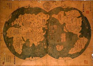
Further articles linked in Kartentisch discuss other exploits of Zhen He, who, as the tale tells, left China in 1405 with a fleet of several hundred ships and equipped with a rudimentary compass for navigation, and was able to round the Cape of Good Hope 76 years prior to Vasco Da Gama, circumanvigated the globe 100 years prior to Magellan, and surveyed Australia 300 years prior to Cook. If this tale is true, it certainly makes Zhen He a major figure in history.
I have little doubt that the Americas and other areas were visited and known to ancient peoples long prior to Columbus, for instance we have the Vinland sagas, Brendan the Navigator's tale, accounts of Basques and other early fishermen who knew the Grand Banks off the Newfoundland coast in Cabot's time, we know that Polynesians came to the coastal areas off of South America, and certainly Arab sailors knew the African and Asian coast and other areas far better than their European counterparts. Certainly some bias and ignorance comes into play, obscuring ancient knowledge. I do think that our predecessors deserve more credit for their knowledge than we generally afford them.
But to what extent does the Zhen He map make sense? It certainly could make good sense for 1763, but does it make sense for 1418? It would be interesting to know more about its history. Perhaps, like the Piri Reis map, it was compiled from multiple sources, some of which may have included Zhen He's accounts, and others which may have been more recent discoveries. At any rate, the map is both remarkable and beautiful. Tests are apparently underway in New Zealand to establish its authenticity.
Technorati tags:
atlas, cartography, China, evidence, geo, Geography, history, map, mapping, maps, navigation, news
Galileo versus NAVSTAR Redux
![]() While I've generally discounted a lot of the Galileo hype, The Space Review today has a very insightful article discussing a different angle on the "arms race" between Galileo and NAVSTAR GPS- the chronograph battle. Essentially their take on it is about the efforts of the Galileo team to build their technology on clocks based on hydrogen masers (Microwave Amplification by Stimulated Emission of Radiation), which yield sub-nanosecond time accuracy, as opposed to the older cesium and rubidium atomic clocks used by the US NAVSTAR GPS effort.
While I've generally discounted a lot of the Galileo hype, The Space Review today has a very insightful article discussing a different angle on the "arms race" between Galileo and NAVSTAR GPS- the chronograph battle. Essentially their take on it is about the efforts of the Galileo team to build their technology on clocks based on hydrogen masers (Microwave Amplification by Stimulated Emission of Radiation), which yield sub-nanosecond time accuracy, as opposed to the older cesium and rubidium atomic clocks used by the US NAVSTAR GPS effort.
The article mentions that the cost of maser-based technology would add $250,000 to the cost, however USAF and the Interagency GPS Executive Board had apparently rejected masers as too costly. I expect that mass of the units and infrastructure to support the varying technologies may also have some more impact on things as well.
Currently Symmetricom has the contract for the next-generation NAVSTAR birds, to use proprietary "optically pumped cesium beam technology", as opposed to the passive hydrogen maser to be used by Galileo.
Will there be an "chronometric arms war"? I'm still not sure there will. Currently NAVSTAR GPS is adequate for most navigation tasks, and the surveying community has developed solutions like CORS to allow millimeter-level processing of points. Ultimately there may be single-receiver solutions that allow realtime millimeter-level accuracy, but I'm not sure that Galileo alone is the solution or enough of a push.
Technorati tags:
eu, Galileo, geo, geodesy, geodetic, Geospatial, gps, location-based, mapping, navigation, news, satellite, science, space, surveying , time
No viruses on Mac?
 Slashdot is carrying some discussion about "smug Mac users"- essentially amounting to ignorance about security, pointing to the high-profile viruses and attacks on Microsoft-based operating systems, as opposed to Mac (and Linux). I think the article didn't completely get to the heart of the matter, as I tend to think that it's a combination of things- the "Get big Corporate Microsoft" mentality of hackers, "script kiddies" and virus coders, along with market share issues and developer support- there's frankly a lot more market share and developer tools available for the Microsoft platform. While the article mainly focused on Mac, with OS X based on *nix-type platforms, it points to the difference between Wintel and other platforms, where with OS X, the virus compile has to be specifically targeted to the OS X and PowerPC platform, (or one of a great many Linux incarnations)... Add to this the aforementioned Commercial versus Open Source issues. The Wintel platform on the other hand tends to be a lot more ubiquitous and predictable, essentially making the hackers' and virus developers' jobs simpler from an economy of scale standpoint.
Technorati tags:
hacking, Intel, linux, Mac, microsoft, open source, OSX, security, virus
Spatial Portals: Gateways to Geographic Information II
I just finished reading through Spatial Portals: Gateways to Geographic Information. The book did a great job of presenting some case studies shedding light on how various enterprises have integrated geospatial data and intelligence using portals, along with other architectural solutions. The case studies presented in the book are listed below, along with URLs, technical details on infrastructure, and some of the interesting/unique points I came away with for each:
Geospatial One Stop
http://gos2.geodata.gov
I'm sure most of you are familiar with GOS, so I won't go into much extraneous detail...
GeoNorge (Norway)
http://www.geonorge.no/
GeoNorge is built on ESRI's Geospatial Portal Toolkit – ArcIMS 4.01 ArcSDE 8.3 and Oracle 9.2
- Systematic Organization of Spatial Information (SOSI) standard (Norway)
http://www.transportdirect.info/
Transport Direct built on ArcIMS, .NET and other technologies
- Integrated roadway and traveler information for UK
MAPSTER (Canada Department of Fisheries and Oceans)
http://www-heb.pac.dfo-mpo.gc.ca/maps/maps-data_e.htm
MAPSTER built on ArcIMS using Moxi Media Internet Mapping Framework (IMF) for OpenGIS – Java/JSP
- Remote access to spatial and tabular data resources
- Access, integrate and display spatial data in other organizations
- Create and display data
- Access OGC Map Services
- Load and work with own data- GPS, CAD and GIS
- Spatial search engine
SCAN (South Carolina Assessment Network – Health)
http://scangis.dhec.sc.gov/scan
SCAN built on ASP.NET, using ArcIMS, MS SQL Server and ArcSDE, drawing from Oracle, SQL Server and DB2 databases.
- Analytical capabilities
- Custom choropleth maps and graphs
- Complex access controls and MOAs
- Standards – International Classification of Disease codes, Social Security Administration, National Association of Public Health Statistics and Information, Centers for Disease Control and Prevention, Health Insurance Portability and Accountability Act (HIPAA)
12M (US Navy Facilities)
Navy intranet
12M built on Win2k/ ASP, MapObjects IMS, Oracle 8/7, Active Directory
- Automated harvest of data
- Automated ETL
- Web Services
GeoInfo One Stop (Hong Kong)
http://www.ozp.tpb.gov.hk/
GeoInfo One Stop (Hong Kong) uses Win2k, .NET, ArcIMS 4.0.1, Java 2, Oracle 9i, ArcSDE 8.3
- Integrated permitting and other workflows
Shell Portal (Oil Exploration)
Shell intranet
Shell Portal built using ArcIMS, SAP, ArcSDE, Oracle Spatial
- United Nations iMaps
- Geography Network
- Federated Search
- Clear data responsibilities
- Validation, authoritative databases
The other project this weekend...
We just got a new puppy yesterday morning- a little female Shetland Sheepdog (Sheltie)/Collie mix. We named her Mystic (or Misty for a nickname) So far, so good. She is very well behaved, and is practically already housebroken. The only tough part is she is a little terrified of going down the stairs. But otherwise, she is doing well, and she is very affectionate and snuggly.
Our 4-year-old son absolutely adores her, and wanted to sleep next to her last night... And being a proper Scots pup, I'm sure my Scottish grandfather would approve...
Technorati tags:
children, dog, dogs, kids, Scotland
Spatial Portals: Gateways to Geographic Information I

This weekend, I finally had a chance to dig in to Spatial Portals: Gateways to Geographic Information, by Winnie Tang and Jan Selwood, a 2005 offering from ESRI Press.
I chose this book, figuring it would tie in with some of the
Geospatial Enterprise Architecture work I am involved in. I only had a chance to read the first couple of chapters today, and generally get the impression that it only offers a high-level overview, without going into much technical detail or delving into specific business processes, architectural, infrastructure and enterprise issues, however it does look like it will provide some excellent case studies.
The projects the book highlights are: Geospatial One Stop, GeoNorge (Norway), Transport Direct (UK), Mapster (Canada), SCAN (Public health in South Carolina), 12M (US Navy) , GeoInfo One Stop (Hong Kong) and Shell.
Technorati tags:
applications, arcgis, arcgis explorer, arcgisexplorer, arcgisserver, architecture, arcims, arcweb, book, books, e-government, ea, enterprise architecture, esri, esri developer network, fea, federal, geo, Geography, Geospatial, gis, gos, mapping, maps, metadata, portal, webmapping
EPA GIS Workgroup
 Looks like I am being asked to present at the EPA 2006 Spring GIS Workgroup Meeting in Annapolis, MD, March 28-31. I am hoping it will be a good opportunity to discuss a common vision for GIS across the EPA enterprise- toward Service-Oriented Architecture, and leveraging the other technology efforts ongoing, such as the ESRI GIS Portal Toolkit and metadata harvesting efforts, identifying and working through the gaps and overlaps in the various repositories and registries scattered throughout the enterprise, and working toward consistency, such as standardized keyword taxonomies, conformed dimensions, and commonalities in metadata to streamline the creation and registration of metadata in Geospatial repositories, UDDI registries, and other places were data, applications and services are housed.
I am very much looking forward to it.
Technorati tags:
architecture, ea, enterprise architecture, environment, environmental protection, epa, esri, events, fea, federal, geo, Geospatial, gis, gos, interoperability, mapping, metadata, remote sensing, service-oriented architecture, SOA, web services
FME 2006

I just got an email from the folks at Safe Software, they are announcing the release of Feature Manipulation Engine 2006 (FME). Per the email,
Earlier this year we had occasion to work with Juan Chu Chow and the team at Safe, as we were trying to deploy OGC WFS services atop a legacy Oracle database, to support Katrina recovery efforts. Safe is responsible for the third party components used in ESRI's Data Interoperability Extension, and I must say, A.) the folks at ESRI Tech Support, Vasu P., Tony Wakim and others did a great job at responding to our calls for help, supporting us and putting us in touch with Safe, and B.) Juan Chu Chow at Safe was extremely responsive and delivered some quick solutions that allowed us to deliver the application quickly.FME 2006 includes over 1000 user-requested enhancements. Some of the new formats now supported in FME 2006 include Google Earth™ KML, GML 3.1.1, and six new raster preview formats. Three significant new features in FME 2006 that are already popular with our test users are Custom Transformers, Shared Directories, and Published Parameters. These three features allow individuals and teams to re-use and share workflows instead of re-inventing them.
Thanks again, guys!
Technorati tags:
applications, epa, esri, esri developer network, extensions, geo, Geospatial, gis, google earth, interoperability, Katrina, mapping, ogc, oracle, tools, web services, wfs
Tennessee Court Case on Trespass
The Tennesseean is reporting of a brawl between Midwestern Gas Transmission Co., of Omaha, Nebraska, and several property owners along a 30-mile stretch of proposed gas transmission line.
Midwestern has evidently argued that State law "gives any condemning authority the right to do surveys without a landowner's consent". Apparently Tennessee Law states that a company's representative can enter land even before a petition seeking condemnation is filed.
A year ago, Midwestern was sued in Sumner County Circuit Court, on the basis that they had not sought any federal permits for the proposed pipeline, and now the issue has been brought back up before the Tennessee Court of Appeals.
It will be interesting to see how this case turns out...
Technorati tags:
eminent domain, land ownership, law, lawsuits, legal issues, pipeline, property, real property, surveying , Tennessee
Continuing Education

The Pennsylvania Registration Board for Engineers, Land Surveyors and Geologists is meeting on January 18th at 9:30AM at the PA Department of State, 2601 North Third Street, Harrisburg, in Board Room C.
As Vice Chair of the Registration Board, one of the items that I have requested be placed on the Agenda is a discussion of Continuing Professional Competency for Engineers. Recently, the Pennsylvania Society of Professional Engineers has pursued legislation to require continuing education for Professional Engineers, in Senate Bill 655. Additionally, the Pennsylvania Society of Land Surveyors Board of Directors has also recently authorized pursuing similar legislation for Land Surveyors.
While I am generally very much in favor of Continuing Professional Competency for licensed professionals, some of the concerns I have regards logistics for implementing such a program at the State Registration Board, along with harmonization of these efforts with model legislation and requirements recommended by NCEES.
I have been reading several articles, but would be curious to hear how other states, professions and jurisdictions handle Continuing Professional Competency.
Technorati tags:
continuing education, continuing professional competency, continuinged, engineering, licencing, licensure, pennsylvania, policy, professional, surveying


