 I found an interesting article on 'Zee News', which describes a forthcoming effort to remap the border between Nepal and Tibet. The 1,400 km border runs along the ruggedest parts of the Himalayas, from the area of Mount Everest and Kanchenjunga toward the Mountain Kingdom of Bhutan the east, through Annapurna and on toward Nanda Devi to the West in India.
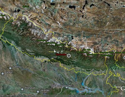
The survey will be a joint effort, between the Chinese government and the Nepalese government. The Surveying and Mapping Bureau of Shaanxi Province will be leading the Chinese effort, with additional Tibetan assets based out of Lhasa, and counterparts from Nepal will join them to form five survey teams. They plan to retrace the boundary using GPS, and to check and maintain the 98 boundary pillars and 79 markers that were placed by previous teams. The border was initially set by treaty in 1961, was first demarcated in 1963, and has been resurveyed in 1979 and 1988. The GPS data will be processed and GIS mapping will be developed from the data.
New Kerala further reports that the Chinese team left Lhasa a few days ago to meet up with the Nepalese contingent in Xigaze in Southern Tibet to begin work. Truly some of the world's most beautiful yet rugged territory. My prayers go out to them on this endeavor.
Technorati tags:
cartography, China, diplomacy, exploration, Geography, geopolitics, Geospatial, gis, gps, Himalayas, map, mapping, Nepal, news, spatial, surveying , Tibet


Hlw dear very helpfull information
Tech news